← Home · Geophysics

Electrical Resistivity and VES Surveys in Santa Rosa

Together, we solve the challenges of tomorrow.

LEARN MORE →

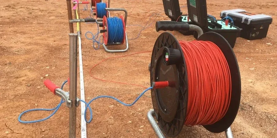
Santa Rosa sits at 164 feet above sea level, but the subsurface tells a deeper story. The alluvial fans of Santa Rosa Creek and the proximity to the Rodgers Creek Fault create a complex electrical signature underground. Electrical resistivity surveys—specifically Vertical Electrical Sounding (VES)—cut through this complexity. The 2014 South Napa earthquake reminded every contractor in Sonoma County that what lies beneath cannot be guessed. VES injects a controlled DC current into the ground and measures the potential difference. The resulting apparent resistivity curve reveals layer boundaries, saturation zones, and clay lenses that standard borings might miss. For projects near the Laguna de Santa Rosa, where saline groundwater interfingers with fresh aquifer recharge, a MASW survey often pairs with VES to tie shear-wave velocity to the resistivity profile, giving a complete geotechnical picture before a single excavator arrives on site.

Resistivity soundings in the Santa Rosa Plain can map the freshwater-saline interface within 20 feet vertically, a critical boundary for well design and dewatering plans.

Methodology and scope

Santa Rosa’s post-1906 rebuild flattened much of the original topography, burying old creek channels and debris fill beneath today’s commercial districts. This urban legacy means resistivity contrasts can be sharp and unpredictable. A Schlumberger array with expanding electrode spacing from 1.5 to 300 meters maps vertical changes efficiently. Our field crew uses a 250-watt transmitter and a high-impedance receiver to push through dry surface gravel common in the eastern foothills. Data inversion runs on Res2DInv software, outputting a true resistivity cross-section. Where the profile suggests a perched water table or a suspected paleochannel, we recommend crossing it with a CPT test for continuous soil behavior data. In vineyard expansion areas west of Highway 101, VES also screens for depth to bedrock before planting decisions. Every sounding is geo-referenced with sub-meter GPS and processed against the Santa Rosa Plain groundwater basin model published by the USGS.
Electrical Resistivity and VES Surveys in Santa Rosa
Technical reference image — Santa Rosa

Site-specific factors

A common mistake is running a VES line without checking for buried utilities first. Downtown Santa Rosa has a dense network of old gas lines, fiber optics, and abandoned streetcar rails that can couple with the injected current and distort the apparent resistivity curve. We cross-reference PG&E maps and use a cable locator before laying out electrodes. Another error is interpreting a low-resistivity zone as groundwater without allowing for the high clay content in the Glen Ellen Formation. Clays can read below 10 ohm-m even when dry. The team always calibrates resistivity results against at least one boring log. A grain size analysis from that calibration bore confirms silt and clay fractions, removing the ambiguity between conductive clay and a true aquifer. Skipping this step has led to dry wells and failed dewatering systems across the county.

Need a geotechnical assessment?

Reply within 24h.

Email: contact@geotechnicalengineering.biz

Technical data

ParameterTypical value
Array configurationSchlumberger (standard), Wenner (optional)
Maximum electrode spread (AB/2)300 m
Typical investigation depth50-80 m below ground surface
Transmitter power250 W (up to 800 V peak)
Data inversion softwareRes2DInv / EarthImager 1D
Reported parameterApparent & true resistivity (ohm-m)

Other technical services

01

1D Vertical Electrical Sounding (VES)

Single-point depth sounding using Schlumberger array. Ideal for water table mapping and bedrock depth estimation.

02

2D Resistivity Imaging

Multi-electrode profile along a line. Resolves lateral changes, fault zones, and contaminant plume boundaries.

03

Groundwater and Salinity Mapping

Targeted surveys near Laguna de Santa Rosa to delineate saline intrusion and fresh aquifer thickness.

Relevant standards

ASTM D6431-18: Standard Guide for Using the Direct Current Resistivity Method, ASCE 7-22: Minimum Design Loads for Buildings and Other Structures, California Building Code (CBC) 2022, Chapter 18: Soils and Foundations

Questions and answers

How deep can a VES survey see in the Santa Rosa Plain?

With a 300-meter AB/2 spacing, we typically reach 50 to 80 meters depth. The exact penetration depends on the subsurface resistivity. Conductive clays limit depth; dry gravels allow deeper current flow. We design the electrode spread on site based on your target depth.

What does resistivity testing cost for a standard site?

A single VES point with full data processing runs between US$580 and US$1,020. A 2D line with 56 electrodes over 300 meters costs more due to field time and inversion complexity. We quote per project after reviewing your site location and objectives.

Can resistivity tell the difference between clay and water?

Not directly. Both saturated clay and fresh groundwater can show resistivity below 20 ohm-m. We always pair VES with a soil boring or CPT log. The boring gives us the actual lithology at one point, which we use to calibrate the resistivity profile across the rest of the site.

How long does a VES survey take in Santa Rosa?

A single VES sounding takes about 45 to 90 minutes of field time, depending on the maximum electrode spread. A 2D line with multiple shots can take half a day. We deliver the inverted resistivity section and a written interpretation within three to five business days after field work.

Location and service area

We serve projects in Santa Rosa and surrounding areas.

View larger map