← Home · Geophysics

Seismic Tomography in Santa Rosa: Refraction and Reflection Surveys for Safer Site Decisions

Together, we solve the challenges of tomorrow.

LEARN MORE →

One of the costliest mistakes we see in Santa Rosa is assuming uniform geology across a site. The area's complex Franciscan assemblage doesn't spread out in neat layers—it twists, shears, and pinches out without warning. A developer recently told us they had "good soil" because a neighbor's report said so, yet their own pad hit weathered melange at 12 feet. That's where seismic tomography changes the game. Instead of drilling blind, refraction and reflection surveys map the velocity structure continuously, revealing hidden bedrock highs, fracture zones, and buried channels that standard borings miss. Pairing this with spt-drilling gives you the physical samples to calibrate the geophysical model, and together they cut the guesswork to nearly zero.

Seismic velocity is the one parameter that connects directly to both stiffness and earthquake response—getting it wrong in Santa Rosa means designing for the wrong site class entirely.

Methodology and scope

Santa Rosa sits near the Rodgers Creek Fault, and much of the valley floor is underlain by alluvial deposits over irregular Franciscan bedrock—often with groundwater within 15 feet of the surface. We routinely acquire seismic refraction lines with 24- or 48-channel arrays, using a sledgehammer or weight-drop source, and process the first breaks through tomographic inversion to produce a 2D velocity cross-section. For deeper targets or layered stratigraphy, reflection profiling images impedance contrasts down to 200 feet or more. When we need to verify low-velocity zones that could indicate loose fill or paleochannels, we cross-check with cpt-test soundings that deliver real-time tip resistance and pore pressure data—helpful where the seismic signal alone leaves ambiguity.
Seismic Tomography in Santa Rosa: Refraction and Reflection Surveys for Safer Site Decisions
Technical reference image — Santa Rosa

Site-specific factors

A mixed-use project off Highway 12 was designed with shallow spread footings based on a handful of borings that showed stiff clay at 8 feet. The seismic refraction line we ran afterward told a different story: a buried channel with P-wave velocities under 1,500 ft/s cut diagonally across the southeast corner, right where the parking structure was planned. That channel was filled with soft organic silt and loose sand, invisible to a boring grid spaced 50 feet apart. Differential settlement across the footing footprint would have been inevitable. By running tomography early and correlating it with targeted test-pits in the low-velocity zones, the structural engineer adjusted bearing depths and added a transition slab, avoiding a post-construction repair that would have cost triple the geophysics budget.

Need a geotechnical assessment?

Reply within 24h.

Email: contact@geotechnicalengineering.biz

Technical data

ParameterTypical value
Survey methodP-wave refraction, S-wave refraction, or P-wave reflection
Typical depth of investigation30 to 200 ft depending on spread length and source energy
Source typeAccelerated weight drop or sledgehammer on aluminum plate
Geophone spacing5 to 10 ft for high-resolution near-surface targets
Shot interval5 to 20 ft with off-end and center shots for reciprocal coverage
Data processingTomographic inversion (non-linear traveltime), iterative ray tracing
Deliverables2D velocity cross-sections, depth-to-bedrock maps, Vs30 estimates, interpretation report

Other technical services

01

P-Wave Refraction Tomography for Bedrock Mapping

The workhorse survey for foundation design in the Santa Rosa plain. We lay out a 230-460 ft spread with 24 or 48 geophones, shoot multiple offsets, and invert the first arrivals into a continuous velocity model. The output is a depth-to-bedrock contour map and a cross-section showing rippability boundaries, weathered zones, and velocity layering that feeds directly into site classification per IBC.

02

Combined Refraction and MASW for Vs30 Profiling

When the structural engineer needs shear-wave velocity to 100 ft for ASCE 7 site class determination, we acquire both P-wave refraction and active-source MASW along the same line. The P-wave tomogram identifies stratigraphic boundaries; the MASW dispersion curve gives the shear-wave velocity profile. Together they deliver a defensible Vs30 value without the cost of a downhole seismic test at every boring location.

03

High-Resolution Seismic Reflection for Fault and Stratigraphic Studies

For deeper targets—mapping the Rodgers Creek Fault trace at depth, imaging basin geometry, or resolving sand-and-gravel aquifer layers—we use a 48-channel reflection spread with a higher-energy source and careful CMP stacking. This method can image reflectors to 300 ft or more and is often the only non-invasive way to see steeply dipping structures in the Franciscan basement.

Relevant standards

ASCE 7-22 (Minimum Design Loads and Associated Criteria for Buildings and Other Structures) — seismic site classification using Vs and Vs30, IBC 2021 (International Building Code) — Section 1613 earthquake loads, referencing ASCE 7 site class determination, ASTM D5777-18 (Standard Guide for Using the Seismic Refraction Method for Subsurface Investigation), ASTM D7128-18 (Standard Guide for Using the Seismic Reflection Method for Shallow Subsurface Investigation), ASTM D7400-19 (Standard Test Methods for Downhole Seismic Testing; cross-referenced for velocity calibration)

Questions and answers

How much does a seismic refraction or reflection survey cost for a typical Santa Rosa lot?

For a half-acre to one-acre residential or light commercial parcel in Santa Rosa, a P-wave refraction line with tomographic processing usually falls between US$2,800 and US$4,900. The spread depends on target depth, number of channels, and whether we are combining it with MASW for Vs30. Reflection surveys run higher because of the denser shot spacing and longer processing time. We provide a fixed-price scope after reviewing your site plan and geotechnical objectives—no open-ended day rates.

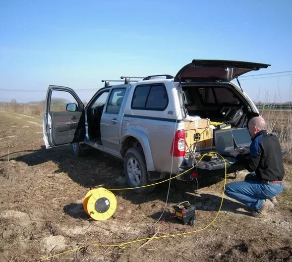
Can seismic tomography replace borings for site classification?

Not entirely, and we would never recommend skipping borings altogether. Seismic tomography gives you continuous velocity information between boreholes and across the entire spread, but it does not provide physical samples for laboratory strength testing or soil description per ASTM D2487. The best approach we see in Santa Rosa is a phased one: run the seismic lines first to map variability, then place borings and CPT soundings exactly where the velocity model shows transitions or anomalies. That way you calibrate the geophysics and minimize the number of invasive tests.

What kind of site conditions in Santa Rosa limit how deep you can image with seismic refraction?

The main limitation is velocity inversion—a soft layer beneath a stiffer layer—which refraction cannot detect because the ray paths never turn back to the surface. Fortunately, that is less common in the Santa Rosa plain than in other parts of the Bay Area, but we still watch for it where saturated loose sands underlie a desiccated clay crust. In those cases we supplement refraction with a reflection profile or with a few CPT soundings to confirm the layering. Urban noise from traffic along Highway 101 can also degrade data quality, so we typically schedule acquisitions on weekends or during low-traffic hours.

Location and service area

We serve projects in Santa Rosa and surrounding areas.

View larger map